The Cost Benefits of Aerial 3D Rendering for Large-Scale
In large-scale projects—whether urban planning, commercial developments, or infrastructure design—visualizing the final outcome is crucial for decision-making. Traditional 2D blueprints and physical models often fail to convey the full scope of a project.
This is where aerial 3D rendering proves invaluable, offering a comprehensive, high-resolution perspective that enhances planning, stakeholder communication, and project efficiency.
Beyond its visual appeal, aerial 3D rendering presents significant cost benefits. By identifying potential design flaws early, optimizing land use, and streamlining approvals, it helps developers avoid costly revisions and delays.
Also, effectively marketing projects before construction begins can attract investors and buyers, ensuring financial viability. In this article, we’ll explore how aerial 3D rendering reduces costs and maximizes value for large-scale projects.
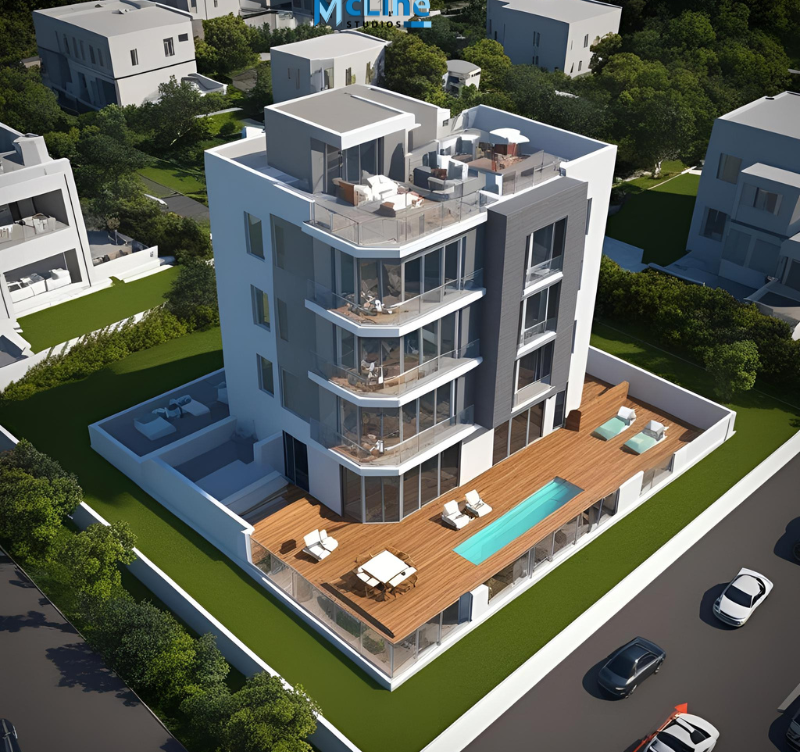
Understanding Aerial 3D Rendering
Aerial 3D rendering is a technology that creates realistic, bird’s-eye views of landscapes, buildings, and entire cityscapes. It is widely used in urban planning, real estate, tourism, and environmental studies.
Using software like AutoCAD, SketchUp, or Lumion, designers create digital models that show how a location looks from above. These models can include roads, parks, buildings, and natural elements like rivers and mountains. The goal is to provide a clear and detailed representation of an area before construction or development takes place.
One of the biggest benefits of aerial 3D rendering is visualization. It helps architects, engineers, and clients see the final project before it is built. Real estate developers use it to market properties by showing potential buyers how neighborhoods will look in the future. City planners rely on it to design better roads and public spaces.
Another advantage is accuracy. Drones and satellite images are often used to collect real-world data, ensuring that the digital model matches the actual location. This helps in making better decisions during planning and construction.
Aerial 3D rendering also saves time and money. Instead of building physical models, developers can make quick changes to digital versions. This reduces mistakes and speeds up the approval process.
In summary, aerial 3D rendering is a powerful tool for visualizing projects from above. It improves planning, enhances marketing, and helps make smarter design choices. As technology improves, this type of rendering will become even more detailed and realistic.
Key Cost Benefits of Aerial 3D Rendering
Aerial 3D rendering is transforming the way architects, developers, and planners visualize projects. It provides a realistic view of large areas, reducing costs and improving efficiency in many ways. Let’s explore the key cost benefits of aerial 3D rendering.
1. Reduced On-Site Survey and Inspection Costs
Conducting physical site surveys can be expensive and time-consuming. Aerial 3D rendering eliminates the need for multiple site visits by offering highly detailed virtual models of the land.
- Fewer travel expenses: Teams don’t have to visit sites as often.
- Faster data collection: Drones and 3D software can capture large areas quickly.
- More accuracy: Digital models reduce human errors in surveys.
2. Minimizing Design Errors and Revisions
Mistakes in design can lead to costly changes during construction. Aerial 3D rendering helps identify potential problems before the building process begins.
- Early detection of issues: Architects and engineers can spot flaws in layouts.
- Better collaboration: Teams can work with precise 3D visuals, reducing miscommunication.
- Lower rework costs: Fewer changes mean lower expenses on labor and materials.
3. Faster Project Approvals and Investment Decisions
Getting approvals from authorities and investors is often a slow process. Aerial 3D rendering speeds it up by providing clear, detailed visual presentations.
- Easier to understand: Stakeholders can see exactly how the project will look.
- Quicker approvals: Authorities and investors can make decisions faster.
- More confidence in investment: Investors can evaluate the feasibility without extensive site visits.
4. Improved Marketing and Sales Efforts
Selling a project before construction begins can be challenging. Aerial 3D rendering makes marketing easier by providing realistic visuals that attract buyers and investors.
- Better promotional materials: High-quality images and videos can be used in brochures and websites.
- Virtual tours: Potential buyers can explore the property remotely.
- Increased sales potential: Stunning 3D visuals make properties more appealing.
5. Efficient Land Use Planning and Infrastructure Development
Proper planning ensures that land and resources are used effectively. Aerial 3D rendering supports better decision-making for urban development and infrastructure projects.
- Optimized land usage: Planners can visualize spaces efficiently before development.
- Better environmental assessments: Helps in evaluating the impact on the surroundings.
- Smoother coordination: Governments and developers can work together with clear visual insights.
3D Designing with Custom Packaging Pro UK
The Long-Term Financial Advantages of Aerial 3D Rendering
Aerial 3D rendering is changing the way businesses and developers plan their projects. It provides a detailed, realistic view of landscapes, buildings, and urban areas. While the upfront cost of 3D rendering may seem high, it offers long-term financial benefits that make it a smart investment.
One major advantage is cost savings in planning and construction. Aerial 3D renderings help architects, engineers, and developers spot potential issues before construction begins. This reduces costly mistakes, delays, and redesigns. By having a clear vision of the project, teams can make better decisions, leading to efficient use of materials and labor.
Another benefit is better marketing and sales. Real estate companies, tourism businesses, and city planners use aerial 3D renderings to showcase projects in a visually appealing way. High-quality images and videos attract investors and buyers, leading to faster sales and higher property values. This means companies can recover their investment in rendering through increased revenue.
Additionally, improved stakeholder communication helps businesses save money. Clear visual presentations reduce misunderstandings between clients, investors, and construction teams. This speeds up approvals and prevents unnecessary revisions, which can be expensive.
Finally, long-term asset management becomes easier. Aerial 3D renderings help in future planning, renovations, and maintenance. Cities, resorts, and large properties can use these renderings for years, reducing the need for new surveys or mapping.
The End Note
Aerial 3D rendering is more than just a visual tool—it’s a cost-effective solution that enhances planning, reduces errors, and accelerates decision-making in large-scale projects. By minimizing site visits, improving design accuracy, streamlining approvals, and boosting marketing efforts, it significantly lowers expenses while maximizing project value.
As technology continues to evolve, aerial 3D rendering will become even more precise and accessible, making it an essential asset for architects, developers, and planners.
Investing in this innovative approach today ensures smoother project execution, better financial outcomes, and long-term success in the ever-growing construction and real estate industries.